Katovice
Katovice | |
|---|---|
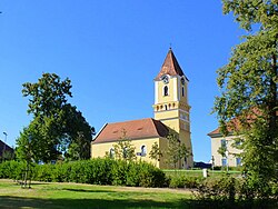
 Church of Saints Philip and James | |
| Coordinates: 49°16′25″N 13°49′49″E / 49.27361°N 13.83028°E | |
| Country | |
| Region | South Bohemian |
| District | Strakonice |
| First mentioned | 1045 |
| Area | |
| • Total | 9.58 km2 (3.70 sq mi) |
| Elevation | 412 m (1,352 ft) |
| Population (2023-01-01)[1] | |
| • Total | 1,352 |
| • Density | 140/km2 (370/sq mi) |
| Time zone | UTC+1 (CET) |
| • Summer (DST) | UTC+2 (CEST) |
| Postal code | 387 11 |
| Website | www |
Katovice is a market town in Strakonice District in the South Bohemian Region of the Czech Republic. It has about 1,400 inhabitants.
Geography[edit]
Katovice is located about 5 kilometres (3 mi) west of Strakonice and 56 km (35 mi) northwest of České Budějovice. It lies on the border of the České Budějovice Basin and Blatná Uplands. The highest point is the hill Katovická hora (formerly known as Kněží hora) at 493 metres (1,617 ft) above sea level. The area of the hill is protected as the Kněží hora Nature Reserve.[2]
The market town is situated on the Otava River, in the historical Prácheňsko region.
History[edit]

Katovice was founded in the 9th or 10th century, probably as a Slavic gold panning settlement on the Otava River and later a market settlement. The first written mention of Katovice is from 1045, when Duke Bretislav I donated the settlement to the Břevnov Monastery. Since then Katovice was mainly an agricultural village.[3]
From the 13th century, Katovice was a serfdom village of the Střela castle. In 1505, Katovice was mentioned as a market town for the first time.[4]
In the 19th century, Katovice slowly developed. It was still an agricultural settlement; other sources of livelihood were pearl hunting and the floating of wood in the form of rafts. In 1867, the railway from Vienna to Cheb was built and helped industrialize Katovice.[5] From 1913 until 1922, graphite was extracted from the steep hill of Kněží hora.[2]
Demographics[edit]
|
|
| ||||||||||||||||||||||||||||||||||||||||||||||||||||||
| Source: Censuses[6][7] | ||||||||||||||||||||||||||||||||||||||||||||||||||||||||
Transport[edit]
Katovice lies on a railway line heading from Strakonice to Klatovy.[8]
Sport[edit]
Local football team SK Otava Katovice participates in lower amateur tiers.
Sights[edit]
The main landmark is the Church of Saints Philip and James. Originally built in the Romanesque style, it was rebuilt to its current form in 1587.[9]
Notable people[edit]
- Václav Matějka (born 1937), film director and screenwriter
References[edit]
- ^ "Population of Municipalities – 1 January 2023". Czech Statistical Office. 2023-05-23.
- ^ a b "Kněží hora u Katovic se může chlubit zbytky hradiště i starým grafitovým dolem" (in Czech). Czech Radio. 2014-07-21. Retrieved 2022-08-29.
- ^ "Starověk" (in Czech). Obec Katovice. Retrieved 2021-08-22.
- ^ "Středověk" (in Czech). Obec Katovice. Retrieved 2021-08-22.
- ^ "Novověk" (in Czech). Obec Katovice. Retrieved 2022-08-29.
- ^ "Historický lexikon obcí České republiky 1869–2011 – Okres Strakonice" (in Czech). Czech Statistical Office. 2015-12-21. pp. 7–8.
- ^ "Population Census 2021: Population by sex". Public Database. Czech Statistical Office. 2021-03-27.
- ^ "Detail stanice Katovice" (in Czech). České dráhy. Retrieved 2023-06-22.
- ^ "Turistika" (in Czech). Obec Katovice. Retrieved 2021-08-22.


