
Chełmsko Śląskie
Chełmsko Śląskie | |
|---|---|
Village | |
 View of Chełmsko Śląskie with the Holy Family church | |
 Chełmsko Śląskie | |
| Coordinates: 50°40′N 16°4′E / 50.667°N 16.067°E | |
| Country | |
| Voivodeship | Lower Silesian |
| County | Kamienna Góra |
| Gmina | Lubawka |
| Population | 1,900 |
Chełmsko Śląskie [ˈxɛu̯mskɔ ˈɕlɔ̃skʲɛ] is a village in the administrative district of Gmina Lubawka, within Kamienna Góra County, Lower Silesian Voivodeship, in south-western Poland, near the border with the Czech Republic.[1]
It lies approximately 7 kilometres (4 mi) south-east of Lubawka, 17 kilometres (11 mi) south of Kamienna Góra, and 86 kilometres (53 mi) south-west of the regional capital Wrocław.
It is a former town. It was first mentioned in 1207 and was granted town rights as late as 1289, when it was part of medieval Poland. It remained a town until 1945. During World War II the Germans established and operated a branch of the Gross-Rosen concentration camp in the town.[2] Chełmsko Śląskie contains numerous historic buildings and structures, the oldest dating back to the Middle Ages.
-
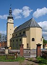 Baroque Holy Family church
 -
 Market Square (Rynek) with historic townhouses
 -
 Old weavers houses from 1707, called the Twelve Apostles
 -
 Gothic sculpture of Hedwig of Silesia, High Duchess consort of Poland and patron saint of Silesia, at the Market Square


.jpg)
References[edit]
- ^ "Central Statistical Office (GUS) - TERYT (National Register of Territorial Land Apportionment Journal)" (in Polish). 2008-06-01.
- ^ "Historia". Starostwo Powiatowe w Kamiennej Górze (in Polish). Retrieved 9 February 2020.
Further reading[edit]
- Franke, Arne (2005). Das schlesische Elysium – Burgen, Schlösser, Herrenhäuser und Parks im Hirschberger Tal (in German). Potsdam: Deutsches Kulturforum östliches Europa e.V. ISBN 978-3-936168-33-4.
| Town and seat |  | |
|---|---|---|
| Villages | ||
| International | |
|---|---|
| National | |
This Kamienna Góra County location article is a stub. You can help Wikipedia by expanding it. |